Honours Field School
The Honours Field School is an important part in the education of 4th year geology students at Rhodes University. It is a capstone course that aims at connecting the academic education in undergraduate and Honours theory courses with acticvities in the field that may resemble the work environment in mineral exploration, as much as this can be done in academic education. Learning activities focus on, but are not limited to, the practical experience of field mapping and analysis.
The Field School is run in April/May as a five-week module, including preparation time, a two-week field course in the Western and Northern Cape Provinces, and sufficient time set aside for subsequent thin section petrography and report preparation.
A significant part of the Field School costs are covered by generous donations from Remote Exploration Services. Without these funds we would not be able to run the field school in its current form and the Department of Geology is very grateful for this support.
The focus of Honours Field School is the development of field skills with emphasis on lithological and structural mapping at 2-5 km2 scale. Although lithological and structural maps are part of the final product, the field school aims essentially to develop descriptive and analytical skills at exposure scale including the classification and interpretation of rocks and structures in terms of the geological environment in which they have formed. This also includes the formation of base metal ore bodies in the O'okiep and Aggeneys areas, and the formation of mineralised pegmatites.
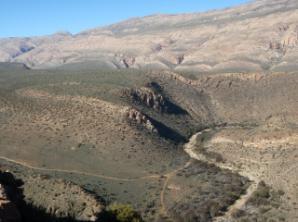
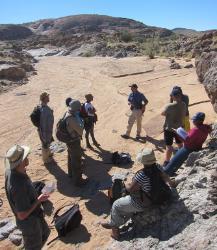
The mapping area near Meiringspoort. Devonian shales and quartzites of the Bockeveld Group.
Exercises include the collection of meaningful structural data using the geological compass, documentation of data and observations in annotated 3D sketches, stereonets, maps and cross sections, and their further assessment in written form. The kinematic analysis and interpretation of shear structures from the brittle field to granulite facies ductile shearing is an important component of the course. In the Northern Cape field areas amphibolite facies metamorhism and deformation allow the estimation of palaeo-temperatures during the metamorphic peak and the regional deformation events. In the Western Cape (Cape Fold Belt) sedimentological features are a relevant field target.
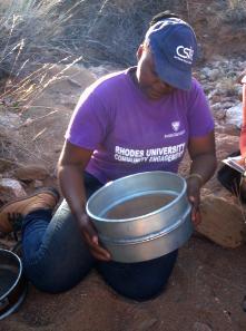
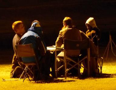
Lutendo Mavhungu (left) taking a stream sediment sample in 2013. Lutendo joined Remote Exploration Services the year thereafter. Map work under floodlights at Raap en Skraap camp site.
Field work is carried out in three different geological environments:
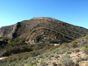
- The Cape Fold Belt, where slates, siltstones and quartzites of the Cape Supergroup underwent folding and thrusting under greenschist facies conditions.
- The lithologically variable amphibolite facies rocks of Bushmanland Group at Aggeneys, which experienced metamorphism, polyphase contractional deformation, and base metal ore body formation during the Namaqua Orogeny between ~1250 and 1000 Ma.
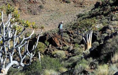
- Metabasites, psammopelitic diatexites, marbles, calc-silicate rocks, granites and magmatic breccias of the Arribees Group in the Swartoup Hills (central Namaqua Belt). This region shows granulite facies metamorphism and deformation at peak and retrograde conditions including high-temperature mylonites and deformation in presence of melt. Li-mineralised pegmatites intruded at the end of the Namqua orogenic phase. Local pseudotachylyte formed during the Pan-African Orogeny at around 512 Ma.
In addition we will undertake a grid mapping exercise and collect stream sediment samples for later chemical analysis and evaluation. The aim of these exercises is the training of field work routines and descriptive and analytical skills that are needed for successful mineral exploration in a variety of crustal settings.
Discussing pseudotachylyte zones in granitic gneisses of the Swartoup Hills (left). Grid mapping exercise in schists and gneisses hosting the Aggeneys base metal deposit.
In addition to the mapping exercises the Field School visits a number of geologically important sites in the Namaqua belt such as:
- “Steep structures” associated with mafic and ultramafic mineralised dykes in the O’okiep copper district
- Historic copper mine at Concordia
- Gossans associated with the Gamsberg zinc deposit
- Late- to post-Namaquan Li-mineralised pegmatites near Kakamas.
Student learning is assessed via practical test assignments in the field and by a report that is produced after the return to Grahamstown. Reporting the results is an important learning objective for which 10 days of time are allocated after the return to Grahamstown. The report is submitted in the format of a professional research paper. Students are encouraged to follow recommendations made in the , which may help to improve the report quality.
Last Modified: Thu, 01 Feb 2018 21:24:41 SAST