During the late 1980s and early 1990s the IWR developed a DOS based modelling system in ‘C’ which became known as HYMAS (Hydrological Modelling Application System) and was used in many hydrological modelling projects including the UNESCO Southern African FRIEND programme.
HYMAS represented an integrated modelling environment with supporting tools for data preparation, data analysis and data display and incorporated a number of different types of rainfall-runoff model as well as other water resource analysis models. During the late 1990s it was clear that a move to the Windows environment was required and the IWR adopted Delphi as their programming language of choice. At the same time, the IWR was involved in developing tools to support the determination of the ecological Reserve and it was decided to develop these as stand-alone Windows compatible programs rather than to add them to the DOS based HYMAS package. Amongst the tools developed, were a generic time series analysis and display package (TSOFT). Additional models were also developed.
During 1999 it became apparent that there was a need to integrate some of the old tools, which still remained part of HYMAS and the new tools, which were developed for a Windows environment. It was therefore decided to embark on the complete conversion of all the HYMAS facilities and tools into an improved and re-designed Windows package that would form the basis for future model development and application. The result is a package referred to as SPATSIM which is developed in Delphi with a GIS front end (using ESRI Map Objects) and where all of the data are stored and accessed through a structured database.
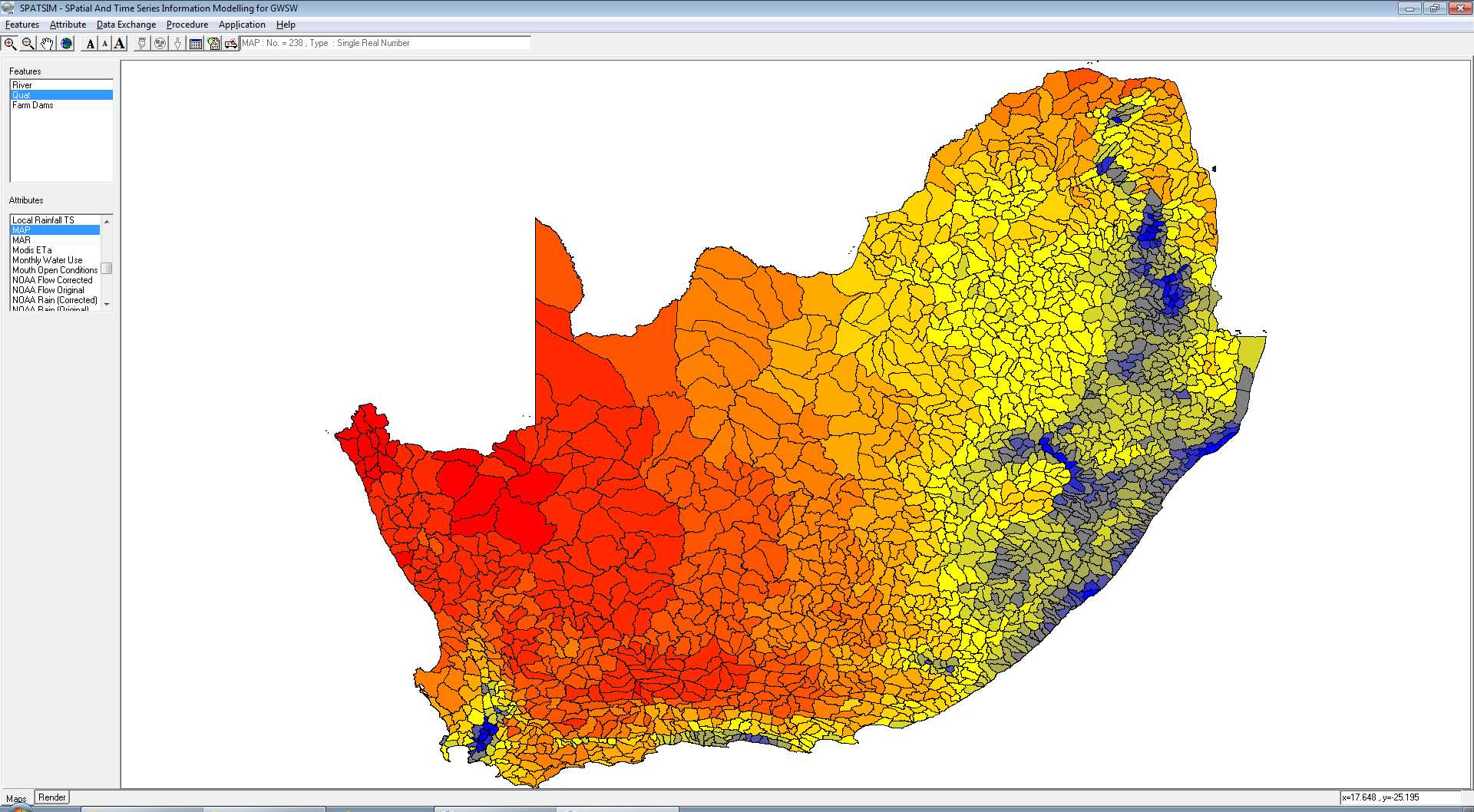
SPATSIM main screen (showing variations in mean annual rainfall for South Africa)
SPATSIM is an integrated hydrology and water resource information management and modelling system. It makes use of ESRI Map Objects and the Delphi programming language to create a data management environment with a spatial information front end and a relational database structure to provide access to a wide range of different types of hydrological and water resource information. The package includes many utilities for importing data of all types, viewing, graphically displaying and editing data, sharing data with other users and further processing data to create new information. It also provides access to a wide range of linked models and data analysis procedures that are typically used in water resource assessments (rainfall-runoff models, design floods, reservoir water balance models) and ecological water requirement assessments. It has been used extensively by the Institute for Water Research and has been distributed to a number of other organisations both within South Africa and elsewhere.
There are many models and data analysis procedures that have been added to SPATSIM over the history of it’s development. Some of those that are more frequently used by the IWR staff and others are listed below:
Many of these models have been the subject of scientific reports and papers in international hydrological journals. There is little doubt that SPATSIM has enhanced the hydrological research capacity of the IWR, as well as several partner organisations that have made use of the software. It has also been used in a large number of consultancy projects, many of which were related to determining the environmental flow requirements of South African rivers, but it has also been used for similar purposes elsewhere in Africa as well for reservoir design, assessing the irrigation potential of an area and for more general basin-wide water resources assessment and planning. Apart from many river systems in South Africa, the IWR versions of the Pitman model have been applied to rivers in India, the Dominican Republic, as well as large basins in Africa (Zambezi, Limpopo, Congo, Okavango, Great Ruaha and others).
A number of powerpoint presentations and linked videos are included as part of the software download package. These can be found in the sub-folder SPATSIM_v3/doc and are based on screen shots combined with some explanatory text. These are in continual development, and to date we provide guidelines for the main SPATSIM interface, the Pitman rainfall-runoff model, the revised desktop reserve model (RDRM) and a new model that is used to estimate channel losses in large arid rivers (Loss Model). Some videos are included for the main SPATSIM guidelines and these are screen capture videos that show the process of completing some tasks/operations within SPATSIM and include some audio explanations.
SPATSIM has been largely developed with the funding support of the Water Research Commission of South Africa and the copyright to the software rests with the WRC and the IWR jointly. However, other organisations have also contributed through adding their models into the SPATSIM system with some assistance from the IWR, or in the case of the International Water Management Institute (IWMI) , through funding the IWR to add new routines or data analysis methods. These contributions are all welcome and gratefully acknowledged. Further reference to supporting organisations is made within the specific relevant components of the software and the help system.
The SPATSIM software as well as the most widely used models that are linked to it has been changed to work with an SQLite database instead of a Paradox database. This change was motivated by the frequent problems experienced in the installation of the Paradox database drivers with newer versions of Windows. The installation process is now much easier and we have experienced few problems since the conversion to using SQLite.
All users should download the new version (SPATSIM_V3) and then convert and move their old version projects to V3. A facility to perform this conversion is available in the SPATSIM_V3\bin folder named ‘convert_to sql.exe’. Simply double click on this executable file and follow the instructions by selecting an application *.ini file from the main folder of the old SPATSIM, convert the database and then move it to the new SPATSIM_V3 folder (all projects are now stored in a SPATSIM_V3\Applications folder). When all your old projects are converted you can uninstall the old version of SPATSIM.
The old versions of all of the linked models will no longer be supported by the IWR at Rhodes University and only the SPATSIM_V3 versions will continue to be supported by code changes and updates. The models that have been converted thus far are:
The models that will be converted in the near future include:
Last Modified: Fri, 19 Jan 2024 16:10:31 SAST