John Arrowsmith (1790-1873) was best known for the 1834 publication London Atlas of Universal Geography, widely considered among the best European sources of maps at the time. In 1810 he had joined the mapmaking firm of his uncle Aaron Arrowsmith, one of the premier publishers of the day, known for rendering the latest geographical findings into impressively detailed maps. Arrowsmith was a founding member of the Royal Geographic Society, which awarded him its gold medal in 1863 for his maps of Australia, North America, Africa, and India.
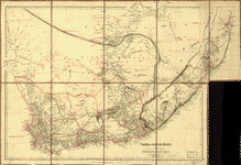
Arrowsmith’s 1842 map of the Cape of Good Hope was produced on the eve of British interventions to stabilize the Cape Colony. Its detailed portrait of coastal trading ports alongside a vast, empty interior highlights just how little was known geographically at a time when Britain’s imperial reach remained largely informal and gave priority to seaward trading over inland expansion.
This map is reproduced from the Library of Congress Map Collections